Training information is located in the Topographic section of the handbook.
View the full Topographical Map Symbol List for 2025 here.
Ridge
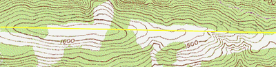
Valley


In this example an intermittent stream runs through the base of the valley. The two pictures are identical. The picture on the right has the valley boundary shaded in yellow for ease of identification.
Peak


These two photos are identical. The knob or peak is depicted by the yellow area. The orange area is the boundary of the slope leading up to the knob or peak of this hill.
Saddle


A saddle is the bottom of the slope between two hills. The yellow areas represent the knobs or peaks of two hills. The orange area is the saddle.
